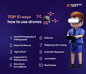
Drones, also known as unmanned aerial vehicles (UAVs), are rapidly gaining popularity for their ability to capture aerial footage and perform tasks that were previously impossible or expensive to do. People have started using drones for a variety of reasons, including photography, videography, surveillance, search and rescue missions, agricultural monitoring, and scientific research. Drones have also become popular among hobbyists and enthusiasts who enjoy flying and exploring the world from above. With advancements in technology, drones have become more affordable, accessible, and user-friendly, which has contributed to their growing popularity in various fields. As a result, drones are being used in industries such as real estate, construction, filmmaking, journalism, and environmental monitoring, among others.
This article will explore the top 10 ways drones can be used and the software they need to operate effectively.
Aerial Photography and Videography
One of the most common uses of drones is aerial photography and videography. One of the most significant advantages of using a drone for aerial photography and videography is the ability to access angles and perspectives that were previously impossible. With the help of a drone, you can capture sweeping landscapes, dramatic cityscapes, and even wildlife in their natural habitats, all from a unique and compelling perspective.
Drones can also be used to capture footage in challenging or dangerous environments, such as high-altitude locations or disaster zones, without putting people at risk. This capability has made drones a valuable tool for journalists, filmmakers, and emergency responders.
Popular software for drone photography includes DJI GO, DroneDeploy, and Pix4D.
Here are some examples of where drones used in video production:
- Film Production
Drones are becoming an integral part of the film industry, enabling filmmakers to capture breathtaking aerial footage for their movies. Films such as “The Wolf of Wall Street,” “The Revenant,” and “Skyfall” have all used drones to capture stunning aerial shots. Drones allow filmmakers to capture aerial footage that was previously too expensive or too dangerous to obtain. Click here to watch the example of how drones are being used in film production.
- Tourism
Drones are being used to capture stunning aerial footage of tourist destinations, providing a unique and compelling perspective on popular destinations. Tourism boards are using drones to create promotional videos that showcase the beauty and attractions of their locations.
- Sports Broadcasting
Drones are becoming a popular tool for sports broadcasters to capture aerial footage of sporting events. Drones allow broadcasters to capture unique angles and perspectives that were previously impossible, adding an extra layer of excitement to sports broadcasts. Click here to watch the example of how drones are being used in sports broadcasting.
Search and Rescue
Drones can also be used for search and rescue operations. Equipped with thermal imaging cameras, drones can search for missing individuals or identify heat signatures in emergency situations.
Software such as DroneSense and Skydio can help with search and rescue operations.
Here are a few examples of how drones are being used in disaster response:
- Search and Rescue
In 2017, following Hurricane Harvey, the Federal Aviation Administration (FAA) authorized the use of drones to aid in search and rescue efforts. Drones were used to search for survivors in flooded areas, assess damage to infrastructure, and identify hazards for first responders.
- Damage Assessment
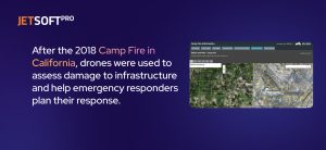
After the 2018 Camp Fire in California, drones were used to assess damage to infrastructure and help emergency responders plan their response. The drones were able to provide high-resolution aerial imagery of the affected areas, allowing officials to identify areas of concern and prioritize resources quickly.
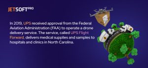
- Delivery of Aid
In Puerto Rico, following Hurricane Maria, a startup called Airwayz used drones to deliver supplies to remote areas that were cut off from traditional modes of transportation. The drones could deliver medical supplies, food, and water to areas inaccessible by road or air.
These examples demonstrate the versatility of drones in disaster response, offering a range of capabilities to aid in response and recovery efforts. As technology continues to improve, drones are likely to become an increasingly important tool in disaster response efforts.
Agriculture
Drones are revolutionizing the agriculture industry by providing farmers with a new tool to optimize crop production, reduce costs, and increase yields. With the help of drones, farmers can gather valuable data on their crops and make informed decisions to improve their farming practices.
One primary way drones are used in agriculture is through aerial imaging. By flying drones equipped with high-resolution cameras over their fields, farmers can capture detailed images of their crops. These images can be analyzed to identify crop health, detect early signs of disease, and monitor crop growth throughout the season.
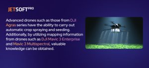
In addition to aerial imaging, drones are being used to spray crops with pesticides and fertilizers. This method of crop spraying is more precise and efficient than traditional methods, as drones can precisely target specific areas of crops that require treatment. This not only reduces the number of chemicals used but also reduces the overall cost of crop spraying.
The software used for agriculture includes DroneDeploy, Pix4D, and Agremo.
Here are some examples of how drones are being used in agriculture:
- Crop Monitoring
Drones equipped with cameras and sensors are being used to monitor crop health and growth. Farmers can identify crop stress, nutrient deficiencies, and disease outbreaks by analyzing this data. This information enables farmers to take corrective action before it’s too late, leading to healthier crops and higher yields.
- Precision Agriculture
Drones are used to create detailed maps of crops, soil, and terrain, allowing farmers to optimize their use of water, fertilizer, and pesticides. This data is used to create precise planting and irrigation schedules, reducing waste and increasing yields.
- Crop Spraying
Drones equipped with sprayers are being used to apply pesticides and fertilizers to crops. This method is more efficient and precise than traditional methods, as drones can target specific areas of crops that require treatment. This results in reduced chemical usage and lower costs.
- Livestock Monitoring
Drones are being used to monitor livestock and identify potential issues such as illness or injury. This enables farmers to take corrective action quickly, leading to healthier livestock and increased yields.
In conclusion, drones are becoming an increasingly valuable tool for farmers, allowing them to gather valuable data on their crops and make informed decisions to improve their farming practices. With the ability to capture detailed aerial imagery, apply pesticides and fertilizers precisely, and monitor livestock, drones are helping farmers to optimize their crop production and reduce costs.
Inspection and Maintenance
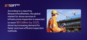
Drones are increasingly being used for infrastructure inspections, offering a cost-effective and efficient way to inspect infrastructure such as bridges, buildings, and power lines.
Drone software for inspection and maintenance includes Airware, DroneDeploy, and Pix4D.
Here are a few examples of how drones are being used for infrastructure inspections:
- Bridge Inspections
In Minnesota, the Department of Transportation has been using drones to inspect bridges since 2015. The drones are equipped with high-resolution cameras and are able to capture detailed images of the bridges, allowing inspectors to identify areas of concern and plan repairs.
- Power Line Inspections
Several utility companies in the United States, such as Duke Energy and Southern Company, use drones to inspect power lines. The drones are equipped with thermal cameras and are able to detect hot spots on the lines, which can indicate potential problems such as faulty connections or overloading.
- Building Inspections
 In the United Kingdom, a company called Iprosurv is using drones to inspect buildings for damage, such as leaks or cracks. The drones are able to capture high-resolution imagery of the buildings, allowing inspectors to identify areas of concern and plan repairs.
- Pipeline Inspections
Enbridge Inc. uses drones to inspect pipelines for damage and leaks in Canada. The drones are equipped with sensors and cameras that can detect temperature or pressure changes, indicating potential pipeline problems.
These examples demonstrate the range of applications for drones in infrastructure inspections, offering a safer, faster, and more cost-effective way to inspect critical infrastructure. As regulations and technology continue to evolve, drones are likely to become an increasingly important tool in infrastructure inspections.
Security and Surveillance
Drones are transforming the field of security and surveillance, providing an aerial perspective that was once unattainable. Their ability to capture high-quality footage, gather real-time data, and reach inaccessible areas by traditional methods has made them invaluable tools for law enforcement, military, and other security professionals. In this article, we will explore the various ways in which drones are used in security and surveillance and provide some examples of their use.
Popular software for security and surveillance includes Airware, DroneDeploy, and Pix4D.
Here are some examples of how such drones were used:
- Border Surveillance Drones
They are being used to monitor borders and detect illegal activity. They can cover large areas quickly and efficiently and provide real-time footage to law enforcement agencies. The US Customs and Border Protection Agency has been using drones to monitor the US-Mexico border since 2005, and the technology has proven to be very effective. The drones can cover vast areas in a short amount of time and provide real-time footage to agents on the ground.
- Crowd Control Drones
This drone type is also used for crowd control at large events such as protests and concerts. They can be equipped with loudspeakers to communicate with crowds and provide real-time footage to law enforcement agencies to help them assess the situation. The French police have been using drones for crowd control since 2016, and the technology has been successful in preventing violent outbreaks.
Crime Prevention and Investigation Drones
This drone type is also being used to prevent crime and investigate criminal activity. They can be used to survey areas where crime is likely to occur and provide real-time footage to law enforcement agencies. In addition, drones can be equipped with thermal imaging cameras to detect heat signatures, making it easier to track suspects at night. The police department in Ensenada, Mexico has been using drones to prevent crime since 2018, and the technology has been successful in reducing crime rates in the area.
- Disaster Response Drones
This drone type is also being used in disaster response situations, such as earthquakes, hurricanes, and wildfires. They can be used to survey affected areas, locate survivors, and provide real-time footage to first responders. In addition, drones can be equipped with sensors to detect gas leaks and other hazardous conditions. The New York City Fire Department has been using drones in disaster response situations since 2017, and the technology has been successful in providing real-time footage to first responders.
- Perimeter Surveillance Drones
This drone type also monitors the perimeters of sensitive facilities, such as power plants and military bases. They can be equipped with high-definition cameras and infrared sensors to detect any suspicious activity. The French military has been using drones for perimeter surveillance since 2014, and the technology has been successful in detecting intruders.
In conclusion, drones are revolutionizing the field of security and surveillance. Their ability to provide real-time footage, cover large areas quickly, and reach areas that are inaccessible by traditional methods has made them invaluable tools for law enforcement, military, and other security professionals. With the development of new technologies, such as AI and machine learning, the potential uses of drones in security and surveillance are endless.
Delivery
Over the past decade, drones have become increasingly popular for a wide range of applications, including delivery services. In recent years, there has been a significant increase in the use of drones for delivery, thanks to their speed, efficiency, and ability to navigate through difficult terrains. Companies like Amazon and Google are testing drone delivery services for small packages. Delivery drones are small, unmanned aerial vehicles (UAVs) that can be programmed to fly to specific locations and drop off packages. They are equipped with GPS, sensors, and cameras, making them capable of navigating through complex environments and avoiding obstacles.
 Software used for drone delivery includes Airware and DroneDeploy
Here are some examples of how drones are being used for delivery:
- Logistics and Supply
The US military has been experimenting with using drones to deliver supplies to troops in the field. In 2019, the US Marine Corps successfully tested a drone that could carry up to 60 pounds of cargo over a distance of 100 kilometers, providing troops with a more efficient and reliable way to receive supplies.
- Cargo Transport
The Swiss company Matternet has been using drones to transport medical samples and supplies between hospitals and labs in Switzerland. The drones can fly up to 20 km round trip and carry payloads weighing up to 2 kg, providing a faster and more efficient way to transport critical medical supplies.
Mapping and Surveying
Drones have become essential in mapping and surveying industries, providing a faster, safer, and more accurate way to collect geospatial data. With the help of drones, surveyors, and mappers can capture aerial imagery and create 3D models of landscapes, structures, and infrastructure.
Software used for mapping and surveying includes DroneDeploy and Pix4D.
- Mapping
In the aftermath of the 2015 Nepal earthquake, drones were used to create detailed maps of the affected areas, allowing aid organizations to understand the damage’s extent better and plan their response. The drones were able to provide high-resolution imagery and 3D models of the affected areas, allowing officials to identify areas of need and plan for rebuilding.
- Land Surveying
Drones equipped with high-resolution cameras and sensors can quickly and accurately survey large areas of land. By flying over the terrain and capturing aerial imagery, surveyors can create detailed maps and 3D models of the land, identifying elevation changes, contours, and topographical features. This information is essential for engineers, architects, and construction companies, as it helps them design and plan projects more efficiently.
- Infrastructure Inspection
Drones can be used to inspect infrastructure such as bridges, buildings, and power lines. Inspectors can identify defects, cracks, and other potential hazards by flying drones over the structures and capturing high-resolution images. This enables them to quickly identify and address issues before they become more significant problems.
- Environmental Mapping
Drones equipped with thermal and multispectral cameras can be used to capture data on environmental conditions such as temperature, vegetation health, and water quality. This data can be used to monitor and manage natural resources, such as forests, wetlands, and water bodies.
In conclusion, drones are providing mapping and surveying industries with a fast, safe, and accurate way to collect geospatial data. By flying drones equipped with high-resolution cameras and sensors, surveyors and mappers can quickly create detailed maps and 3D models of landscapes, structures, and infrastructure. The applications of drones in mapping and surveying are wide-ranging, from land surveying to environmental mapping and disaster mapping.
Scientific Research
Drones have been increasingly used in scientific research, providing a unique platform to gather data from a variety of remote locations. With their ability to access difficult-to-reach areas, drones can assist scientists in gathering data on wildlife, environmental conditions, and geological features.
The software used for scientific research includes Airware and DroneDeploy.
Here are some examples of how drones are being used in scientific research:
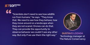
- Wildlife Research
Drones are being used to study wildlife populations, behavior, and migration patterns. Researchers can attach cameras and sensors to drones, allowing them to capture images and data that would otherwise be impossible to obtain. For example, drones equipped with thermal imaging cameras can detect and locate animals in the dark, allowing researchers to track their movements and monitor their populations.
- Environmental Monitoring
Drones are being used to monitor environmental conditions, such as air and water quality. Researchers can collect data on temperature, humidity, wind speed, and other environmental factors by attaching sensors to drones. This data can be used to study climate change, weather patterns, and pollution.
- Geology Research
Drones are being used to study geological features, such as volcanoes and glaciers. By flying drones equipped with cameras and sensors over these features, researchers can capture detailed images and data that can help them better understand how they work. For example, drones can be used to measure the temperature of volcanic lava or to study the melting of glaciers.
- Archaeology Research
Drones are being used to study ancient archaeological sites, allowing researchers to obtain high-resolution images and 3D models of sites that are difficult to access. This data can be used to study ancient cities’ layouts and identify previously unknown archaeological features.
In conclusion, drones are providing scientists with valuable tools to gather data from remote locations. By attaching cameras and sensors to drones, researchers can obtain high-resolution images and data on wildlife, environmental conditions, geological features, and archaeological sites. The applications of drones in scientific research are wide-ranging, from wildlife research to geology research and archaeology research.
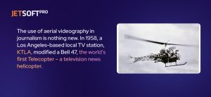
Journalism
Drones are changing the way journalists report news, providing a unique perspective that was once unattainable. Their ability to capture high-quality footage and reach areas that are inaccessible by traditional methods has made them an invaluable tool for news organizations.
Popular software for journalism includes DJI GO, DroneDeploy, and Pix4D.
Here are some examples of how drones are being used in Journalism:
- News Coverage
Drones are being used to capture footage of breaking news events, such as natural disasters and protests. They can provide a bird’s-eye view of the scene, giving viewers a better understanding of the situation. In addition, drones can be used to capture footage of areas that are difficult to access, such as disaster zones and war zones. The BBC has been using drones to cover news events since 2013, and the technology has been successful in providing unique footage to viewers.
- Sports Coverage
Drones are being used to capture footage of sporting events, providing a new level of excitement for viewers. They can be used to follow athletes and capture unique angles of the action. In addition, drones can be used to capture footage of outdoor sporting events, such as cycling races and marathons. The NBC Sports Network has been using drones to cover sporting events since 2014, and the technology has been successful in providing unique footage to viewers.
- Travel Journalism
Drones are also being used in travel journalism, providing a new level of detail to stories about exotic locations. They can be used to capture footage of landmarks, natural wonders, and other important sights. In addition, drones can be used to capture footage of areas that are difficult to access, such as remote islands and mountain peaks. The travel magazine Travel + Leisure has been using drones in their reporting since 2016, and the technology has been successful in providing a new level of detail to its stories.
In conclusion, drones are transforming the field of journalism, providing a new level of access and detail to stories. With the development of new technologies, such as 360-degree cameras and virtual reality, the potential uses of drones in journalism are endless.
Real Estate
Real estate agents are also using drones to capture aerial images and footage of properties. Drones can provide potential buyers with a better view of the property and its surroundings. Software used for real estate includes DJI GO, DroneDeploy, and Pix4D.
Here are some examples of how drones are being used in Real Estate:
- Real estate
Drones are becoming increasingly popular in the real estate industry for capturing stunning aerial shots of properties. Real estate agents and homeowners use drones to capture aerial footage of properties, showcasing the property’s features and location in a way that traditional ground-level photography can’t match.
Time to join the drone revolution with JetSoftPro
Drones have emerged as a game-changing technology that is revolutionizing the way we live, work, and do business. With their ability to capture high-quality aerial footage, collect data, and perform tasks that are difficult or impossible for humans, drones have quickly become indispensable tools in a wide range of industries and fields.
This article delves into the top 10 ways to utilize drones and the corresponding software required for each application. Drones are becoming increasingly innovative in their use cases, from inspecting transportation and infrastructure to aiding in disaster response and military operations. They save time, cut costs, and improve safety.
However, the possibilities of drones do not end there. As technology advances, drones can revolutionize industries and unlock new opportunities. With expertly designed software, businesses can streamline their operations, researchers can collect data, and hobbyists can take stunning aerial photographs. Custom technology solutions, such as those developed by JetSoftPro, can facilitate this transformation.
JetSoftPro, a leading custom software development company, can help develop great solutions tailored to individual needs. They have received outstanding reviews on Clutch, a B2B review platform, for their high-quality work, professionalism, and timely delivery.
So, whether you’re a business owner, researcher, or hobbyist, JetSoftPro’s custom technology solutions can assist in achieving your goals. Join the drone revolution and see how this incredible technology, alongside JetSoftPro’s expertise, can change how you work and live.